| Tuesday May 22, 2018, 1:30 pm |
Waldo Tobler Memorial Session #1
|
|
| |
The Evolution of Cartography in the Digital Age: From Digitizing Vertices to Intelligent Maps (pdf) |
E. Lynn Usery1 and Dalia Varanka1
1US Geological Survey
|
| |
Area-Preserving Simplification of Polygon Features (pdf) |
Barry Kronenfeld1, Lawrence Stanislawski2, Tyler Brockmeyer1, and Barbara Buttenfield3
1Eastern Illinois University; 2US Geological Survey; 3University of Colorado
|
| |
Active Symbolism: Towards a New Theoretical Paradigm for Statistical Cartography (pdf) |
Marc Armstrong, University of Iowa |
| |
Analysis of the Adoption of StoryMaps (pdf) |
Aileen Buckley1 and Kevin Butler1
1Esri
|
| |
|
|
| Tuesday May 22, 2018, 3:00 pm |
Waldo Tobler Memorial Session #2
|
|
| |
Embracing Visualization as a Key Element in Computational Movement Analytics |
Somayeh Dodge, University of Minnesota |
| |
Generalizing Linear Stream Features to Preserve Sinuosity for Analysis and Display: A Pilot Study in Multi-Scale Data Science (pdf) |
Lawrence Stanislawski1, Barry Kronenfeld2, Barbara Buttenfield3, and Tyler Brockmeyer1
1US Geological Survey; 2Eastern Illinois University;3University of Colorado
|
| |
From Point Clouds to Tactile Maps: How Lidar and Photogrammetry Can Improve Maps for People with Visual Impairments |
Thomas Pingel1, Matthew Mendez1, and Earle Isibue1
1Northern Illinois University
|
| |
MapStudy: An Open Source Survey Tool for Researching Interactive Web Maps (pdf) |
Robert Roth1, Carl Sack2, Meghan Kelly1, Nick Lally1, and Kristen Vincent1
1University of Wisconsin - Madison; 2Fond du Lac Tribal & Community College
|
| |
|
|
| Tuesday May 22, 2018, 5:30 - 7:30 pm |
Poster Session
|
|
| |
Understanding of Within City Electricity Consumption Patterns through Settlement Characterization |
Pranab K. Roy Chowdhury1,2, Jeanette Weaver1, Eric Weber1, Dalton Lunga1, Amy Rose1 and Budhendra L. Bhaduri1,2
1Oak Ridge National Laboratory; 2The University of Tennessee
|
| |
Automatic Alignment of Geographic Features in Contemporary Vector Data and Georeferenced Historical Maps Using Reinforcement Learning |
Weiwei Duan1 and Yao-Yi Chiang1
1University of Southern California
|
| |
Optimizing Activity Locations in GIS using a Multi-Objective Trajectory Approach |
Xin Feng1, Shaohua Wang1,2, Alan T. Murray1, Yuanpei Cao3, Song Gao4
1University of California - Santa Barbara; 2Chinese Academy of Science; 3AdColony, Inc.; 4University of Wisconsin - Madison
|
| |
Unmanned Aircraft Systems and the Atmospheric Boundary Layer: A New Frontier for Geospatial Data Science? |
Amy Frazier1 and Benjamin Hemingway1
1Oklahoma State University
|
| |
Towards Healthy Cities: Presenting a Spatial Framework for Prevalence of Diseases
|
Monica Haddad, Iowa State University
|
|
Winner, Student Scholarship Award
|
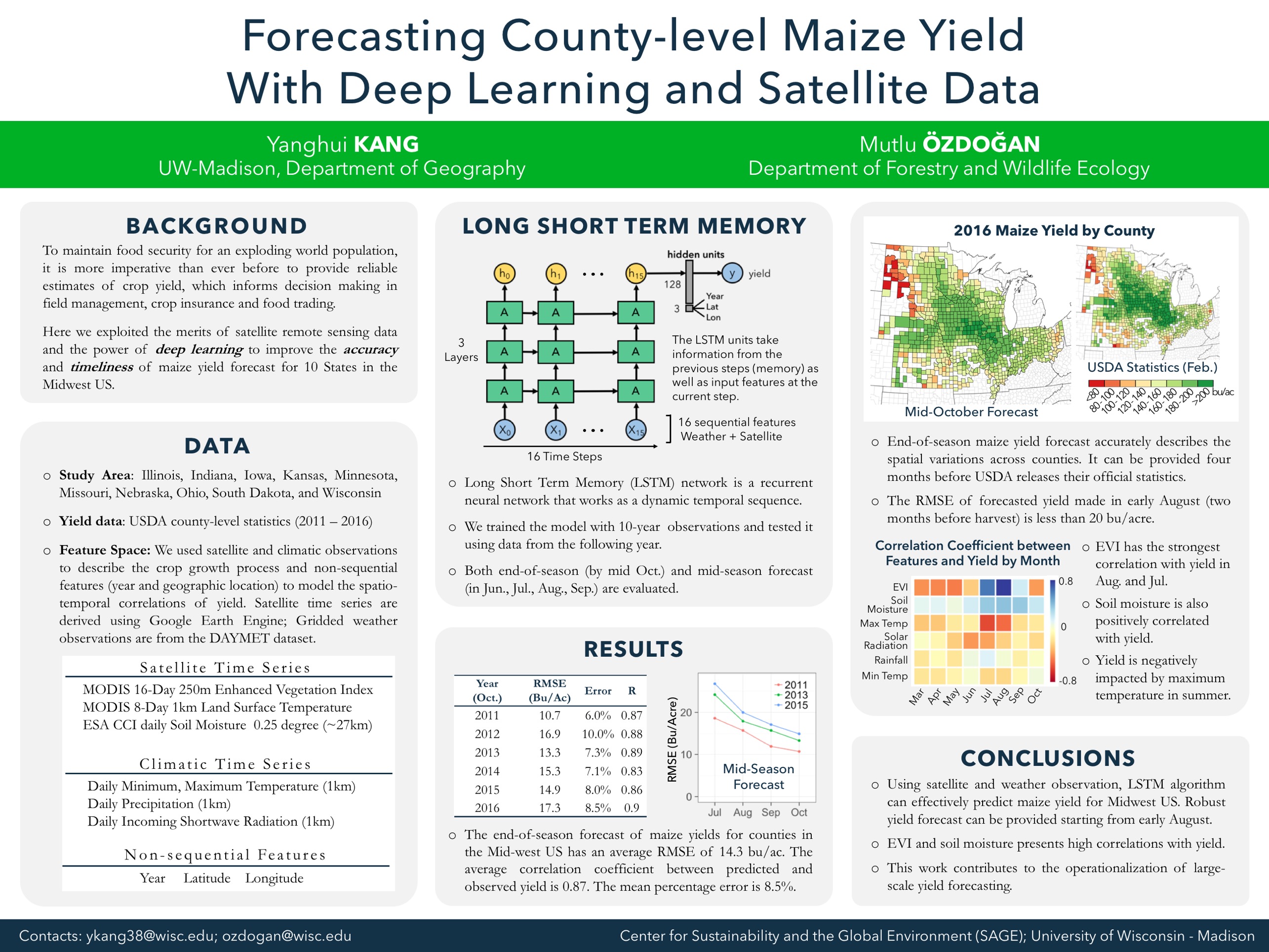
Predicting County-Level Maize Yield with Deep Learning and Satellite Data |
Yanghui Kang1 and Mutlu Ozdogan1
1University of Wisconsin - Madison
|
 |
Incorporating Changes in Multi-scale Databases |
Dan Lee1, Nobbir Ahmed1, and Iffat Chowdhury1
1Esri
|
|
Winner, Student Scholarship Award
|
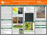
Viewshed Analysis for UAS Flight Planning |
Samuel Levin1 and May Yuan1
1University of Texas - Dallas
|
| |
Flyover Country |
Ross Thorn1, Simon Goring1, Robert Roth1, Shane Loeffler2, and Amy Myrbo2
1University of Wiscosin - Madison; 2University of Minnesota
|
| |
Identifying Crime Patterns in Mexico Using Geo-social Mining and Clustering |
Roberto Zagal-Flores1, Miguel-Felix Mata-Rivera1, Christophe Claramunt2, and Edgar Armando Catalán-Salgado3
1UPIITA-IPN, Mexico; 2Naval Academy Research Institute; 3ESCOM-IPN, Mexico
|
| |
|
|
| Wednesday, May 23, 2018, 8:45 am |
Session #3: Deep Learning
|
|
| |
Deep Convolutional Neural Networks for Map Type Classification (pdf) |
Xiran Zhou1 and Jun Liu2
1Arizona State University; 2Shenzhen Institutes of Advanced Technology, Chinese Academy of Sciences
|
| |
Automatic Generation of Precisely Delineated Geographic Features from Georeferenced Historical Maps Using Deep Learning (pdf) |
Weiwei Duan1, Yao-Yi Chiang1, Craig Knoblock1, Johannes Uhl2, and Stefan Leyk2
1University of Southern California; 2University of Colorado
|
| |
Exploring the Potential of Deep Learning for Settlement Symbol Extraction from Historical Map Documents
|
Johannes Uhl1, Stefan Leyk1; Yao-Yi Chiang2, Weiwei Duan2, and Craig Knoblock2
1University of Colorado; 2University of Southern California
|
| |
|
|
| Wednesday May 23, 2018, 1:45 pm |
Session #4: Lightning Talks
|
|
| |
A 3D Spatial Optimization Problem for Determining Optimal Locations for Bluetooth Beacon Placement (pdf) |
Brent Dell1 and May Yuan1
1University of Texas - Dallas
|
| |
Aerial Imaging and Lidar Point Cloud Fusion for Low-Order Stream Identification (pdf) |
Ethan Shavers1 and Lawrence Stanislawski1
1US Geological Survey
|
| |
Design-based Approaches to Identify Causation in GIS Education Research (pdf) |
Ola Ahlqvist, The Ohio State University |
| |
Using Deep Learning and Google Street View to Quantify the Shade Provision of Street Trees in Boston, Massachusetts |
Xiaojiang Li, Massachusetts Institute of Technology |
| |
Web-Based Demo to Show a Land Use Code Ontology (pdf) |
Nancy Wiegand, University of Wisconsin - Madison |
| |
|
|
| Wednesday May 23, 2018, 3:15 pm |
Session #5: Transportation & Movement
|
|
| |
Geospatial Machine Learning: Predicting Accident-Prone Road Segments Using GIS and Data Mining |
Xiao Li1, Daniel Goldberg1, Tracy Hammond1, and Xingchen Chen1
1Texas A&M University
|
| |
Development of a GIS-Based Model to Examine Alternative Scenarios for Last-Mile Freight Delivery (pdf) |
Amy Moore, Oak Ridge National Lab |
| |
Spatiotemporal Modeling of Traffic Accident Using Network Kernel Density Estimation and Space Syntax Analysis: A Case Study in Dallas, Texas, USA (pdf) |
Benjamin Acker1 and May Yuan1
1University of Texas - Dallas
|
| |
A Crowdsourcing-Geocomputational Framework of Mobile Crowd Estimation |
T. Edwin Chow, Texas State University |
| |
|
|
| Thursday, May 24, 2018, 8:45 am |
Session #6: Integration of Big Disparate Data
|
|
| |
The Internet of Things and Fast Data Streams: Prospects for Geospatial Data Science in Emerging Information Ecosystems (pdf) |
Marc Armstrong1, Shaowen Wang2, and Zhe Zhang2
1University of Iowa; 2University of Illinois - Urbana Champaign
|
| |
Unmanned Aerial Vehicle Logistics Modeling and Performance: A Demonstration of Integrative Data Science (pdf) |
Kevin Curtin, University of Alabama
|
| |
EWN-KDF: A Knowledge Discovery Framework to Understand the Energy Water Nexus |
Anne Berres1, Rajasekar Karthik1, Alexandre Sorokine1, Phillip Nugent1, Melissa Allen1, Ryan McManamay1, Varun Chandola2, Arshad Zaidi2, Jibonananda Sanyal1, Budhendra Bhaduri1
1Oak Ridge National Laboratory; 2University at Buffalo
|
| |
|
|
| Thursday May 24, 2018, 10:45 am |
Session #7: Visualization
|
|
| |
Maps as Graphs: An Implementation for Cartographic Retrieval of Linked Geographical Data (pdf) |
Dalia Varanka1, William Baumer2, and Logan Powell2
1US Geological Survey; 2Missouri University of Science and Technology
|
| |
Geovisual Text Analytics for Exploring Public Discourse on Twitter: a Case Study of Immigration Tweets Before and After the January 27, 2017 Travel Ban (pdf) |
Caglar Koylu1, Bryce Dietrich1, and Ryan Larson1
1University of Iowa
|
| |
GeoVisual Analytics for the Exploration of Complex Movement Patterns on Arterial Roads (pdf) |
Irma Kveladze1 and Niels Agerholm1
1Aalborg University, Denmark
|
| |
Visualizing Sea Level Rise Induced Migration Using Hexagonal Grids (pdf) |
Hoda Tahami1, Bo Zhao1, David Wrathall1, and Majidreza Hosseinieh Farahani1
1Oregon State University
|